A recurring shift in ocean temperature and atmospheric pressure across the tropical Pacific that alters weather across much of the world. It is the largest source of year-to-year climate variability after the seasons, and it can be forecast months ahead.
Trade winds blow from east to west across the tropical Pacific. They push surface water westward, piling warm water in the western Pacific near Indonesia, where sea level is measurably higher and the ocean surface warmer.
In the east, off South America, that displaced water is replaced by cold water rising from below. This upwelling brings nutrients to the surface and supports one of the world's most productive fisheries.
The warm western pool drives rising air, cloud and heavy rainfall over Indonesia, while the cool eastern Pacific has descending air and arid coasts in Peru and Chile.
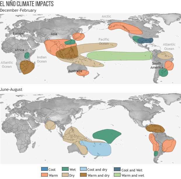
During El Nino the trade winds weaken or reverse. Warm water spreads back eastward across the Pacific, upwelling off South America is suppressed, and the eastern Pacific becomes unusually warm.
Because tropical rainfall follows the warmest water, the region of heavy convection shifts eastward, which reorganises atmospheric circulation far beyond the tropics.
The name comes from Peruvian fishermen, who observed that a warm current appeared off the coast around Christmas, and called it the boy child. The fishery collapses during these events because the nutrient supply fails.
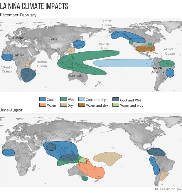
La Nina is the opposite phase. Trade winds strengthen, warm water piles further west, and the eastern Pacific becomes cooler than normal.
It is not simply the absence of El Nino but a distinct state, and its effects are broadly opposite to El Nino's without being an exact mirror.
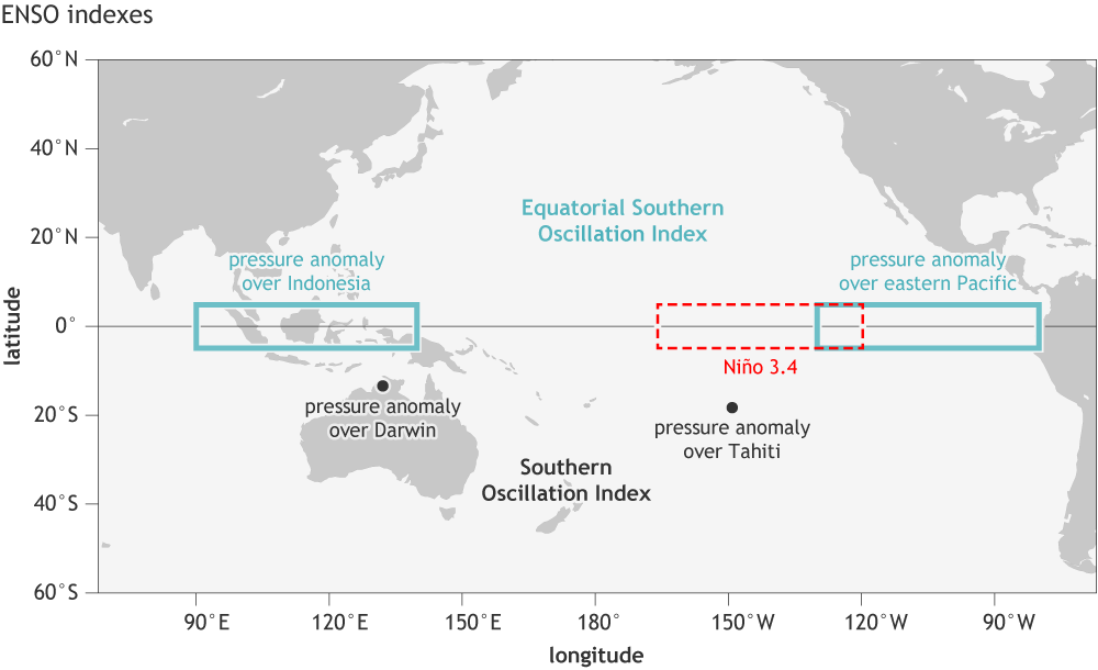
The two phases together with the neutral state form the El Nino Southern Oscillation, usually abbreviated ENSO. The Southern Oscillation part refers to the atmospheric pressure seesaw between the eastern and western Pacific, identified by Gilbert Walker in the 1920s, decades before the ocean connection was made. Jacob Bjerknes established in the 1960s that the ocean and atmosphere components are the same phenomenon, coupled to one another.
The coupling is what makes the event grow. Weaker trade winds allow warm water eastward, the warmer eastern ocean weakens the winds further, and the feedback amplifies a small initial disturbance into a full event.
The reversal comes from the ocean's slower response. Waves travelling within the ocean, reflecting off the western and eastern boundaries, return after months and act to reverse the temperature anomaly, which is why events last roughly a year rather than persisting indefinitely.
Events recur irregularly, typically every two to seven years, and the irregularity is intrinsic rather than a failure of understanding.
The shift in tropical convection alters atmospheric waves that propagate into the middle latitudes, which is how a Pacific ocean anomaly affects weather elsewhere.
El Nino is typically associated with drought in Indonesia, Australia and parts of southern Africa and India, heavy rainfall and flooding in Peru and Ecuador, a wetter southern United States and drier north, a weaker Atlantic hurricane season, and a rise in global average temperature, since the ocean releases heat to the atmosphere.
La Nina is broadly associated with the reverse, including wetter conditions in Australia and Indonesia and a more active Atlantic hurricane season.
These are tendencies rather than certainties. Any individual event may not produce the typical pattern, and the strength of the relationship varies by region, with some connections far more reliable than others.
Because the ocean changes slowly and the coupling is understood, ENSO is predictable months in advance, which makes it the main basis of seasonal climate forecasting.
An array of moored buoys across the tropical Pacific, established after the very strong event of 1982 and 1983 was not detected until it was underway, measures temperature and winds continuously and feeds forecasting models.
Forecasts are used for agricultural planning, water and reservoir management, fisheries, disease preparedness in regions where outbreaks track rainfall, and insurance.
Skill is limited by the spring predictability barrier, a period each year when forecasts made across it are markedly less reliable.
ENSO is natural variability and predates industrial emissions, recorded in corals and sediments over centuries.
How warming affects it is an active question. There is evidence that strong events may become more frequent and that the impacts of any given event are amplified by a warmer baseline, and projections of the underlying oscillation itself remain uncertain.
The distinction matters for interpreting individual years, since a strong El Nino raises global average temperature temporarily and a La Nina lowers it, superimposed on the longer-term trend.
ENSO is the clearest demonstration that ocean and atmosphere form a single coupled system, and that a change in one part of the tropical Pacific propagates into weather on every continent.
It is also the main practical success of seasonal forecasting. Predicting weather beyond about ten days is not possible, and predicting the tendency of a season months ahead is, because it is governed by the slowly varying ocean rather than by the atmosphere alone.